 Back to List
Best pond liner to use for reservoir project is a kind of anti-seepage and moisture-proof waterproof building materials, and its anti-seepage performance mainly depends on the anti-seepage performance of plastic film. penetration performance.
Best pond liner to use for reservoir project is made of polyethylene resin by adding a certain proportion of carbon black masterbatch, anti-aging agent, antioxidant, ultraviolet absorber, stabilizer, etc. , it is widely used for solid waste containment, mining and water containment applications.
Case analysis
Location: Brazil
Product: 1.5mm HDPE Geomembrane Pond Liner
Project: Large Reservoir Project
Issue
The water storage capacity of the reservoir is 0.7Mm³, which is impounded by the filled road embankment with a height of 9m and a length of 280m. The lack of cohesive soil material on the project site meant that the dam design was based on artificial waterproofing elements, including concrete core walls and geomembranes. Early contractor engagement is client-initiated to provide constructability, schedule, and cost inputs during the conceptual design phase. A dam containing an upstream best pond liner to use was ultimately chosen for economic and constructability reasons.
The dam uses an upstream sloping HDPE geomembrane attached to the upstream toe by a concrete base on the bedrock. The geomembrane is covered with a padded and torn transition layer to provide better protection against puncture and aging.
The project site is located in an area of beautiful natural beauty. The visual impact of the dam and the restoration of the surrounding area after construction are important factors for the promotion of the scheme. Planning permission was granted in June 2010 and ground surveys, profile design and energy yield studies were completed by the end of 2010. Project funders accepted the “financeable” design in early 2011, and construction began almost immediately thereafter.
A published 1:50,000 geological map of the area shows the solid geology of the Jura Quartzite Formation. the entire project. Quartzite ranges from weak to very strong, grey angular, highly fractured rocks with orange/yellow staining on some joint surfaces. Basalt is a very solid dark grey/black rock with extensive discontinuities.
Solution
The embankment has a top width of 3.5m and is set at a level of 138.0mOD with an upstream and downstream slope of 1 to 2.5. Landscaping fill is mainly placed on the lower right side to reduce the visual impact of the embankment. The waterproofing element is formed by an upstream sloping geomembrane covered with graded granular fill and ripped soil.
All peat and organic material was excavated from the dam’s footprint and temporarily disposed of at a nearby location by end dumping prior to restoration and landscaping works. The peat thickness varies throughout the dam site, with a maximum of about 2.5m, and the temporary cutting slope of the peat is roughly stable at around 1 to 1 throughout the construction period. Except for surface water discharge and filtration through straw, no special dewatering engineering bag/geotextile is required before returning to combustion. Glacier cultivated formations were trimmed and proof rolled prior to infill work.
The best pond liner to useis attached at the upstream toe to a concrete toe base cast on the prepared rock surface with a sloped concrete wedge (similar to the CFRD toe base) to provide a flat waterproofing surface to which the geomembrane is attached. The best pond liner to use is fixed on top of the anchor trench.
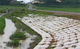
A 1.5mm thick dual texture HDPE geomembrane lining was chosen for the waterproofing elements. The total coverage area is approximately 50000 square meters, with mechanical seals on the upstream toe base and all ancillary structures. Special details were required to secure the geomembrane to the spillway and intake works to accommodate differential settlement of embankment fill and rigid structures on bedrock. Anchoring of the top is provided by grinding the geomembrane into the anchoring trench. The upstream embankment face was prepared by trimming and compacting the slope with vibrating plates mounted on heavy excavators. This produces a regular surface free of potholes and angular fragments of quartzite. The surface was partially masked with sand to create any local irregularities, and a 300 g/m2 “felt” type geotextile was placed on the surface, the geomembrane was spread out and fastened to the toes and tops. The geomembrane is weighed using a temporary sandbag until securely fastened and welded.
The geomembrane is supplied in 7.5 m wide rolls and all field welds are made using an automatic wide wedge welder to create double seam welds, all air tested at 2 bar pressure.
Field trials were conducted prior to installation of the geomembrane
Demonstrate that the contractor’s backfill and compaction methods do not adversely affect the integrity of the geomembrane. A section of the geomembrane was backfilled and later excavated to assess the condition of the geomembrane. The tests showed no signs of puncture or breakage and the contractor’s method of work was accepted. The geomembrane was installed in two installments to accommodate the contractor’s river diversion sequence.
Due to the relatively short length of the membrane, installation and welding were very quick, although work was temporarily suspended during high winds and rain for safety reasons.